Colombia – que chévere es el cocuy

(how cool is el cocuy)

After 2 weeks of voluntary teaching computer skills in the Yurac Yacu community at the foot of the Cordillera Blanca, we went out for a couple of its summits. As reported before, the Cordillera isn’t enjoying its best climbing season, but nevertheless we managed to climb three 5000+ peaks. A report on that 10 day onslaught will apear after summer.

Starting the descent from the the summit of Nevado Ishinca (5530m) while Nevado Ranrapalca (6162m) touches cloud in the background. Huascaran National Park. Cordillera Blanca. North-Peru. A more detailed report from those escapades will follow in a future blog post.

Starting the descent from the the summit of Nevado Ishinca (5530m) while Nevado Ranrapalca (6162m) touches cloud in the background. Huascaran National Park. Cordillera Blanca. North-Peru. A more detailed report from those escapades will follow in a future blog post.

Flash forward to end of July. Time is ticking. Our gap year is closing in. Back in Colombia. The colonial town of el Cocuy, a former FARC guerrillas bastion, becomes our penultimate hideout on our south american rambles. Suposed to host Colombian’s finest Andean scenery in its nearby, namesake national park, we endure the arduous, tyring busride from Villa de Leyva to El Cocuy, just a stone throw away from the the Venezuelan border. 280km. 11 hours drive. You got the bumpy picture!

Café Bellavista. Locals in their traditional ruana, a poncho-style outer garment made of sheep wool. El Cocuy. Boyaca. Colombia.

Café Bellavista. Locals in their traditional ruana, a poncho-style outer garment made of sheep wool. El Cocuy. Boyaca. Colombia.

If Parque Nacional Natural el Cocuy would be part of the gringo trails in southern Peru or Ecuador, its sattelite town would host an incredible set of hostels, restaurants and the like to cater the hords of tourists. In el Cocuy, authenticity survives. It’s so tranquil we can’t believe this place was a no-go for foreigners up to a couple of years ago. Slowly some gringos arrive, but only in the supposed dry season from december to mid-february. Even now, amid European and American summer holidays, tourists are needles in a haystack.

“Buenas tardes. Que les vaya bien.” Altough everything looks so tranquil in the far away Andean town, heavy armed forces still patrol the streets, betraying Colombia’s recent troubled past. El Cocuy. Colombia.

Once again Colombian locals unfold as extremely friendly, helpful, talkative and hospitable. We immediatly got the hang of the place and choose to stay for more then backpacking its mountains. We introduce ourself in town as teachers and within half a day we organize a 10-day adult course in computer skills at the local library (equiped with some computers) which we will start after our trek. Within an hour, word spreads town and we have to close at 28 inscriptions. The local high school also invites us to help out in computer classes during our stay, so during daytime we’ll provide guest lectures to all grades.

After 48 hours of patiently waiting out horrendously, bad weather in the Sisuma hut, a clear morning finally gave us the oppurtunity to leave for the heart of the park. PNN El Cocuy. Colombia.

After 48 hours of patiently waiting out horrendously, bad weather in the Sisuma hut, a clear morning finally gave us the oppurtunity to leave for the heart of the park. PNN El Cocuy. Colombia.

Up and over slabs along the banks of Laguna de la Plaza. Parque Nacional Natural El Cocuy. Colombia.

Up and over slabs along the banks of Laguna de la Plaza. Parque Nacional Natural El Cocuy. Colombia.

Can we still be surprised by nature after a year of backpacking extravaganza in the world’s wildest corners? Little did we know Parque Nacional Natural el Cocuy would strike us with some much awe. Mountain forecast didn’t look promising when we left uphill, so after a first attempt to cross the first pass we had to stay put in a hut for 48 hours until the range’s notorious blizzard conditions cleared for a second attempt. We had to convince a party of 2 German-Austrian medics for not bailing and at least try to continue in these conditions, because their mountain guide wanted to bail after crossing 2 passes in way-too-much snow for his liking. Gird your backpack, lace your shoes and go take a hike with us on our our last trek of the gap year, through a remote mountainous area of glaciers, lakes and high altitude grassland lined with dramatic rock walls.

Frailejónes. An intruiging, endemic plant to this part of the Andes.

Frailejónes. An intruiging, endemic plant to this part of the Andes.

Close-up of our favourite Andean plant. Meet miss Fray Le Jónes! PNN EL Cocuy. Colombia.

Close-up of our favourite Andean plant. Meet miss Fray Le Jónes! PNN EL Cocuy. Colombia.

Fog crawls in from the Amazon. Frailejónes shape the fairytale scenery. PNN El Cocuy. Colombia.

Fog crawls in from the Amazon. Frailejónes shape the fairytale scenery. PNN El Cocuy. Colombia.

Laguna de la Plaza drains towards the Amazon through some nice waterfalls. PNN El Cocuy. Colombia.

Laguna de la Plaza drains towards the Amazon through some nice waterfalls. PNN El Cocuy. Colombia.

Pure, granite walls crawl out of the fog. PNN El Cocuy. Colombia.

Pure, granite walls crawl out of the fog. PNN El Cocuy. Colombia.

Lupines on the valley floor. Valle de los Cojines. PNN El Cocuy. Colombia.

Lupines on the valley floor. Valle de los Cojines. PNN El Cocuy. Colombia.

Bivy near Laguna Panuelo. PNN El Cocuy. Colombia.

Bivy near Laguna Panuelo. PNN El Cocuy. Colombia.

Crossing the snowy Paso el Castillo (4700m), until 10 years ago, this pass was glaciated. PNN El Cocuy. Colombia.

Crossing the snowy Paso el Castillo (4700m), until 10 years ago, this pass was glaciated. PNN El Cocuy. Colombia.

Crossing the marshes of Valle de los Cojines. PNN El Cocuy. Colombia.

Crossing the marshes of Valle de los Cojines. PNN El Cocuy. Colombia.

Flores de senecio near Paso de la Sierra (4650m) with the towering 1000m east-cliffs of Nevado Ritacuba Blanco (5410m). PNN El Cocuy. Colombia.

Flores de senecio near Paso de la Sierra (4650m) with the towering 1000m east-cliffs of Nevado Ritacuba Blanco (5410m). PNN El Cocuy. Colombia.

Descending towards Lago de la Isla. PNN El Cocuy. Colombia.

Descending towards Lago de la Isla. PNN El Cocuy. Colombia.

Local farmer on his way towards the Uwa indigenous reservate which overlaps with the national park. Colombia.

Local farmer on his way towards the Uwa indigenous reservate which overlaps with the national park. Colombia.

There’s an ongoing controversy for the moment between the national park authorities and the indigenous Uwa community which have overlap grounds with the park. The Uwa regard the core of the park as sacred ground and want to close it for foreigners. Let’s hope they find an outcome in this, because this would be a shame if this beautiful part of the world becomes inaccesbible.

Locals greeting us every morning on our way to high school. El Cocuy. Colombia.

Locals greeting us every morning on our way to high school. El Cocuy. Colombia.

El Cocuy's students at the local high school. El Cocuy. Colombia.

El Cocuy’s students at the local high school. El Cocuy. Colombia.

Teaching computer skills to local students. Guturiez high school. El Cocuy. Colombia.

Teaching computer skills to local students. Guturiez high school. El Cocuy. Colombia.

Time to shut the door on our gap year and start dreaming of new adventures...

Time to shut the door on our gap year and start dreaming of new adventures…

More picturefun in our online album.

End of the gap year? Waaaaaaaaaaaah! You must be kidding!

End of the gap year? Waaaaaaaaaaaah! You must be kidding!

Advertisement

Peru – Cordillera Blanca, un salto en el nube

[Cordillera Blanca, a jump in the cloud]

So here we are volunteering at the foot of the highest, tropical mountain range on the globe. Between preperations and the actual computer classes we got out for a two week solo trip in the remote and rugged northern part of the mesmerizing range. In for some Inca Kola?

The Yurac Yacu education centre (3650m) at the foot of the Cordillera Blanca. Our volunteering grounds of the last month. Nevado Churup (5493m) cliffs the sky.

The dry season seems not to get out of its hibernation this year. It’s cloudy, rainy and it doesn’t cool of in the night. Not even freezing at bivaouc spots at 4500m. With 2 early casualties in early season on Alpamayo, it promises not to be the Peruvian’s best Andean summer.

Flowering lupines at the foot of  Nevado Ulta (5875m). Huascaran National Park. Cordillera Blanca. Peru.

Flowering lupines at the foot of Nevado Ulta (5875m). Huascaran National Park. Cordillera Blanca. Peru.

We don’t know what it is up here, but every freakin’ gringo we meet in Huaraz is here for hiking the Santa Cruz trail. While it has it merits, there is so much more to explore, even on short overnight trips. So many empty valleys and forgotten ridges with uninterupted breathtaking views and the lone, friendly Quechua poppin’ up. It’s extreme diverse and easy to go backpacking in the Cordillera Blanca. You’ll be treated with the most incredible alpine scenery, rivaling anything in the Himalayas. Moreover, it’s so accessible, that you’re in the wild and among neck muscle defying peaks within an hour after sipping your coffee at one of the multiple, excellent hangouts in Huaraz. Stretching north along the Callejón de Huaylas you’ll find easy acces into the different west-east carving quebradas (deep carved valleys). Hey ho, let’s go!

I tried to put the trip report into another picture rollercoaster. Enjoy!

There is more picturefun in our flickr set over here.

Sidetracked magazine improved their website and has another article where we contribute. Go have a look!

There is not a single trail build for touristic purposes in the Cordillera Blanca. All of them are Inca or pre-Colombian era and were the only way to cross the range until a couple of decades. Here we are closing in towards Punta Yanayacu pass at 4850m.  Huascaran National Park. Cordillera Blanca. Peru.

There is not a single trail build for touristic purposes in the Cordillera Blanca. All of them are Inca or pre-Colombian era and were the only way to cross the range until a couple of decades. Here we are closing in towards Punta Yanayacu pass at 4850m. Huascaran National Park. Cordillera Blanca. Peru.

Seccluded biviaouc at 4200m in the Quebrada Matara. Sharp Nevado Ulta (5875m) and ridgy, glaciated Contrahierbas (6036m) rising high above the Quebrada Ulta. Huascaran National Park. Cordillera Blanca. Peru.

It is said that if one tears of a leaf of the Tarqoy flower, it will rain. Too much tearing thus, this year. Huascaran National Park. Cordillera Blanca. Peru.

It is said that if one tears of a leaf of the Tarqoy flower, it will rain. Too much tearing thus, this year. Huascaran National Park. Cordillera Blanca. Peru.

A continuous roar of avalanches spill from the cliffs of Contrahierbas (6036m). Deep down in the valley lies the Andean village of Yanama. Huascaran National Park. Cordillera Blanca. Peru.

A continuous roar of avalanches spill from the cliffs of Contrahierbas (6036m). Deep down in the valley lies the Andean village of Yanama. Huascaran National Park. Cordillera Blanca. Peru.

Leaving the Andean village of Yanama through farming lands towards the Quebrada Huaripampa. The acutal glaciated peaks are hidden in thick clouds, unusual for the time of the year.

Leaving the Andean village of Yanama through farming lands towards the Quebrada Huaripampa. The acutal glaciated peaks are hidden in thick clouds, unusual for the time of the year.

Massive deforestation left the Cordillera Blanca denuded before the range (above 4000m) was put in conservation  through the Huascaran National Park in 1975. Only some patches of the Queñua trees thrive in remote valleys and give the wanderer a feeling on how fairytale it must have been before mr. Human came along. Cordillera Blanca. Peru.

Massive deforestation left the Cordillera Blanca denuded before the range (above 4000m) was put in conservation through the Huascaran National Park in 1975. Only some patches of the Queñua trees thrive in remote valleys and give the wanderer a feeling on how fairytale it must have been before mr. Human came along. Cordillera Blanca. Peru.

Conservation, Peruvian style. Gringos pay 65 soles (25US$) National Park fee to the ranger (orange jacket), while locals are allowed to cut vulnerable trees just at the spot. Huascaran National Park. Cordillera Blanca. Peru.

Conservation, Peruvian style. Gringos pay 65 soles (25US$) National Park fee to the ranger (orange jacket), while locals are allowed to cut vulnerable trees just at the spot. Huascaran National Park. Cordillera Blanca. Peru.

Snapshot! Chacraraju (6112m) and Piramide (5885m) reveal for a 60-second marvel during breakfast. Quebrada Paria. Huascaran National Park. Cordillera Blanca. Peru.

Snapshot! Chacraraju (6112m) and Piramide (5885m) reveal for a 60-second marvel during breakfast. Quebrada Paria. Huascaran National Park. Cordillera Blanca. Peru.

Coming down from Alto de Pucaraju pass (4650m) with the east face of Taulliraju (5830m) touching cloud. Can you spot Katrijn? Huascaran National Park. Cordillera Blanca. Peru.

Coming down from Alto de Pucaraju pass (4650m) with the east face of Taulliraju (5830m) touching cloud. Can you spot Katrijn? Huascaran National Park. Cordillera Blanca. Peru.

Quechua people roasting a cow's head for supper purposes. Jancapampa. Cordillera Blanca. Peru.

Quechua people roasting a cow’s head for supper purposes. Jancapampa. Cordillera Blanca. Peru.

Crossing an unnamed ridge into the remote northern part of the Cordillera Blanca. The multipeak Pucajirca (6046m) absorbs all humidity from the Amazonas. Huascaran National Park. Cordillera Blanca. Peru.

Crossing an unnamed ridge into the remote northern part of the Cordillera Blanca. The multipeak Pucajirca (6046m) absorbs all humidity from the Amazonas. Huascaran National Park. Cordillera Blanca. Peru.

Another lonely bivaouc at Laguna Huecracocha, while the Andes awakes. How desolate these wild places are above 4000m, the flora cannot recover, because overgrazing is still a huge ecosystem corrupter, even after almost 40 years of conservation. Huascaran National Park. Cordillera Blanca. Peru.

Another lonely bivaouc at Laguna Huecracocha, while the Andes awakes. How desolate these wild places are above 4000m, the flora cannot recover, because overgrazing is still a huge ecosystem corrupter, even after almost 40 years of conservation. Huascaran National Park. Cordillera Blanca. Peru.

Leaving another lonely bivaouc spot at the foot of the north face of Pucajirca (6046m). Huascaran National Park. Cordillera Blanca. Peru.

Leaving another lonely bivaouc spot at the foot of the north face of Pucajirca (6046m). Huascaran National Park. Cordillera Blanca. Peru.

Alpine splendisism. Azure Laguna Jancarurish is fed by the massive glaciers of Alpamayo (5947m) and Quitaraju (6036m), both out of sight. Santa Cruz Grande (6241m) appears at the right. Huascaran National Park. Cordillera Blanca. Peru.

Alpine splendisism. Azure Laguna Jancarurish is fed by the massive glaciers of Alpamayo (5947m) and Quitaraju (6036m), both out of sight. Santa Cruz Grande (6241m) appears at the right. Huascaran National Park. Cordillera Blanca. Peru.

Alpenglow on the perfect pyramid north face of Alpamayo (5947m). The mountain was named “The Most Beautiful Mountain in the World” in 1966 after an international survey among climbers, mountaineers, exploreres and photographers. Huascaran National Park. Cordillera Blanca. Peru.

Laguna Cullicocha reflects the complete Santa Cruz (6241m) massif. Huascaran National Park. Cordillera Blanca. Peru.

Laguna Cullicocha reflects the complete Santa Cruz (6241m) massif. Huascaran National Park. Cordillera Blanca. Peru.

Bivaouc high above the Callejón de Huaylas. Sun sets over the Cordillera Negra, the Blanca's icefree parallel range to the west. Huascaran National Park. Cordillera Blanca. Peru.

Bivaouc high above the Callejón de Huaylas. Sun sets over the Cordillera Negra, the Blanca’s icefree parallel range to the west. Huascaran National Park. Cordillera Blanca. Peru.

Dropping down the Callejón de Huaylas towards the village of Hualcayan after spending a week above 4000m. The Cordillera Negra stretching out west. Huascaran National Park. Cordillera Blanca. Peru.

Dropping down the Callejón de Huaylas towards the village of Hualcayan after spending a week above 4000m. The Cordillera Negra stretching out west. Huascaran National Park. Cordillera Blanca. Peru.

Anyone who traveled in Peru surely tried the Inca Kola. The gummy ball flavored soft drink. Yummie! Caraz. Ancash, Peru.

Anyone who traveled in Peru surely tried the Inca Kola. The gummy ball flavored soft drink. Yummie! Caraz. Ancash, Peru.

Colourful Quechua women come down to the valley to sell their crops. Caraz. Ancash, Peru.

Colourful Quechua women come down to the valley to sell their crops. Caraz. Ancash, Peru.

Colombia – dias flojas en el Caribe

(slack days on the Carribean)

It took quite some time to overcome the Patagonian blues during an almost-week-long bus strike which held us hostage at Bariloche. It gave us some space to prepare some ideas for things to do on the last 3 months of our gap year. Enters Colombia in the story line.

An early morning ramble on the jungle-clad beaches of the Tayrona National Park, Carribean Colombia.

An early morning ramble on the jungle-clad beaches of the Tayrona National Park, Carribean Colombia.

Impressive boulders ramble the wild Carribean coastline. Tayrona National Park. Colombia.

Impressive boulders ramble the wild Carribean coastline. Tayrona National Park. Colombia.

The mystique country at the northwestern tip of the continent, has had its share of good-news-shows to keep even the most determined tourist out of the country. Narcotic urban legend Pablo, revolutionary jungle terrorists and an enduring armed conflict, predominating the last decade’s headlines, didn’t help much on the image of the country. During the last decade, however, the government has done extreme investement to stabilize the country and improve security (the display of heavy, armed soldiers along the major roads is remarkable), hence widening the gates for tourism.

https://i0.wp.com/farm3.staticflickr.com/2851/8908277644_b681f279d9_b.jpg

Boulder-strewn, overgrown jungle coast of Carribean Colombia. That Indiana Jones kinda feeling was never far away when sweating our way towards the pre-Colombian hidden ruines of el Pueblito. Tayrona National Park. Colombia.

A parade of hard working ants. Tayrona National Park. Carribean Colombia.

A parade of hard working ants. Tayrona National Park. Carribean Colombia.

Despite the bad news, Colombia has always been a secret pearl among backpackin’ gringos in South America. Extremely helpful and friendly locals. A country of superlatives. With any possible ecosystem imaginable, it could keep you occupied for well, quite some time. Colombia is one of those megadiverse countries in biodiversity. Does it have our attention? A yes it is.

Cooling off near the village of Minca. Sierra Nevada National Park. Carribean Colombia.

Cooling off near the village of Minca. Sierra Nevada National Park. Carribean Colombia.

Cloud forrest. Sierra Nevada de Santa Marta National Park. Carribean Colombia.

Cloud forrest. Sierra Nevada de Santa Marta National Park. Carribean Colombia.

After studying the different climate zones and our first 2 week timeframe in Colombia we left for the Carribean. Beach people as we are (ahum), we were suprised by the opportunities for alternatives to beach-chillin’ up here. Once we got a bit used to the year-round humid heat, we were off exploring some of the surprising national parks and hidden villages this northern part of Colombia is rich. So we’ve been overwhelmed by such wonderfull places like the San Bernardo archipelago, the jungle beaches of Tayrona and the world’s highest coastal range of Santa Marta.

Biking through the sleepy, fishing hamlet of La Boquila near Cartagena, Carribean Colombia.

Biking through the sleepy, fishing hamlet of La Boquila near Cartagena, Carribean Colombia.

Need some avocado? Santiago de Tolú. Sucre. Colombia.

Need some avocado? Santiago de Tolú. Sucre. Colombia.

The posh Boca Grande district contrasts with the fortified, medieval walls around the historic centre of Cartagena. A Unesco World Heritage site. Carribean Colombia.

The posh Boca Grande district contrasts with the fortified, medieval walls around the historic centre of Cartagena. A Unesco World Heritage site. Carribean Colombia.

Preparing for some paddling around the mangroves of Tintipán island. Archipiélago de San Bernardo National Park. Carribean Colombia.

Preparing for some paddling around the mangroves of Tintipán island. Archipiélago de San Bernardo National Park. Carribean Colombia.

Creolen kids on the Tintipan island. Archipiélago de San Bernardo. Carribean Colombia.

Creolen kids on the Tintipan island. Archipiélago de San Bernardo. Carribean Colombia.

Fishermen's canoes. Tintipán island. Archipiélago de San Bernardo National Park. Carribean Colombia.

Fishermen’s canoes. Tintipán island. Archipiélago de San Bernardo National Park. Carribean Colombia.

End of May. Goodbye Colombia, see you in July. Enters the Peruvian Cordillera Blanca in our schedule. We’re here for mountaineering and thru-hiking the upcoming 6-7 weeks. Huaraz. Peruvian Andean’s answer to Chamonix. Acclimatisation days before the high altitude weeks coming.

Sun sets over the southern summits of the Cordillera Blanca. Ancash, Peru.

Sun sets over the southern summits of the Cordillera Blanca. Ancash, Peru.

And then we meet Diana, who introduces us to her community development project high up in the Andes at the foot of the mezmerizing Cordillera Blanca. Before we even realize it, our planned schedule changes with the snap of a finger. We’re volunteering. It doesn’t have to be hauling a backpack up the moutains all the time. Exciting weeks coming up. There’s also hiking and mountaineering coming up. You know us…

Happy students leave the Yurac Yacu community center, where we will teach students and teachers some computing skills during the next coming weeks.

Happy students leave the Yurac Yacu community center, where we will teach students and teachers some computing skills during the next coming weeks.

Sunday afternoon gathering in the Yurac Yacu community center, where you can find us enhancing local people skills the upcoming weeks.

Sunday afternoon gathering in the Yurac Yacu community center, where you can find us enhancing local people skills the upcoming weeks.

Andean Alliance is focused on supporting “grass roots” community development planning capabilities and implementing programs that strengthen the educational and economic base of Andean communities while enhancing their social and environmental conditions.

Andean Alliance

For more pictures from our couple of weeks, please click:

Carribean Colombia
Huaraz. Cordillera Blanca. Peru.

With love from the Mud Volcano de Lodo. San Antero. Carribean Colombia.

With love from the Mud Volcano de Lodo. San Antero. Carribean Colombia.

Patagonia – un paseo otoñal entre la roca, el hielo y la lenga

(an autumnal ramble between rock, ice and a lenga tree)

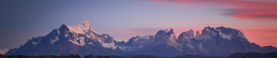
Our thru-hike of Aysén ends in the sleepy, frontier town of Villa o’Higgins, where the dusty Carretera Austral dirt road arrived only 12 years ago, surrounded by snowy mountain peaks, lush lenga forrests and the northeastern arm of the huge, turquoise Lago O’Higgins. Nature halts all human progress. The vast Southern Patagonian Ice Field dominates to the south and west.

Dark clouds gather and strong winds blow over the southwestern arm of the 1000 km² Lago O'Higgins in Deep Patagonia, Aysen, Chile. Its turquoise melting waters from the Southen Patagonian Ice Cap, drain to the Pacific through the threatened Rio Pascua. Notice the waves on the lake.

Dark clouds gather and strong winds blow over the southwestern arm of the 1000 km² Lago O’Higgins in Deep Patagonia, Aysen, Chile. Its turquoise melting waters from the Southen Patagonian Ice Cap, drain to the Pacific through the threatened Rio Pascua. Notice the waves on the lake.

An exploration hike up an unnamed peak, raising high above the Eastern arm of the Lago O'Higgins, Aysen, Patagonia, Chile. Remark the Chilea border post of Candelario Mancilla down left.

An exploration hike up an unnamed peak, raising high above the Eastern arm of the Lago O’Higgins, Aysen, Patagonia, Chile. Remark the Chilea border post of Candelario Mancilla down left.

Some marketing boys/girls woudl call this remote part Deep Patagonia. Non-motorized travellers, nevertheless, don’t have to retrace hundreds of kms north to find a passable and legal border crossing over the Andes into Argentina to reach the more touristic hot spots in Southern Patagonia. A passenger-only launch gets hikers and bikers to the other side of Lago O’Higgins, where they can get off at Candelario Mancilla, an estancia and Chilean border post of carabineros. The majority of the hikers and bikers who brave this remote launch crossing, leave immediatly for the 25km hike through dense forrest to the by-foot-reached-only Argentine border post at Lago del Desierto, which will lead them to nearby El Chalten, right into the heart of the Los Glaciares National Park.

Easter Sunday. Approaching the autumnal treeline towards a pass to reach the southeastern arm of the Lago O'Higgins. Aysen. Patagonia. Chile.

Easter Sunday. Approaching the autumnal treeline towards a pass to reach the southeastern arm of the Lago O’Higgins. Aysen. Patagonia. Chile.

Uninterupted, virgin Patagonian forrest towards the south. The granite tower of Cerro Fitz Roy (3359m) dominates the skyline 100km south of this peek through.

Uninterupted, virgin Patagonian forrest towards the south. The granite tower of Cerro Fitz Roy (3359m) dominates the skyline 100km south of this peek through.

Despite the incredible remoteness of this part of Patagonia, some colonizers live secculed lives with some cattle tucked between the lake, virgin forrest and the towering ice cap, with the only possibility to get away 3 times a month when the forementioned launch tuffs by (weather permitting). In stead of heading to Lago del Desierto, as do the majority of the 2500 foottravelers doing this bordercrossing in summer season, we get off to visit these remote colonizers and try to explore the ridges and shores of the southern arms of the Lago O’Higgins, with big hopes of uninterupted views over the ice field.

Glaciar Chico flowing from the Southern Patagonian Ice Cap into the southeastern arm of the Lago O'Higgins. Easter sunday. Aysen. Patagonia. Chile.

Glaciar Chico flowing from the Southern Patagonian Ice Cap into the southeastern arm of the Lago O’Higgins. Easter sunday. Aysen. Patagonia. Chile.

Luigo Mancilla, a gaucho living on the southeastern arm of the Lago O'Higgins, rows us over the small channel to get to another penninsula which will bring us closer the Southen Patagonian Ice Cap.

Luigo Mancilla, a gaucho living on the southeastern arm of the Lago O’Higgins, rows us over the small channel to get to another penninsula which will bring us closer the Southen Patagonian Ice Cap.

Strong winds blow of the ice cap, forming impressive lenticulars over the pass we walked over a couple hours ago. Aysen. Patagonia. Chile.

Strong winds blow of the ice cap, forming impressive lenticulars over the pass we walked over a couple hours ago. Aysen. Patagonia. Chile.

Cordón GAEA, towering above a tarn. On route towards uniterupted views of the Southern Patagonian Ice Cap. Aysen. Patagonia. Chile.

Cordón GAEA, towering above a tarn. On route towards uniterupted views of the Southern Patagonian Ice Cap. Aysen. Patagonia. Chile.

The Glaciar O'Higgins calving from the Southern Patagonian Ice Cap into the southwestern arm of the Lago O'Higgins. The glacier front sticks out 60m above the water surface. It takes 2 days from Candelario Mancilla to get to this remote rocky outcrop towering high above the ice. Aysen. Patagonia. Chile.

The Glaciar O’Higgins calving from the Southern Patagonian Ice Cap into the southwestern arm of the Lago O’Higgins. The glacier front sticks out 60m above the water surface. It takes 2 days from Candelario Mancilla to get to this remote rocky outcrop towering high above the ice. Aysen. Patagonia. Chile.

Sun rises over the Cordon O'Higgins at the seccluded rancho of Don Lagos. Aysen. Patagonia. Chile.

Sun rises over the Cordon O’Higgins at the seccluded rancho of Don Lagos. Aysen. Patagonia. Chile.

https://i0.wp.com/farm9.staticflickr.com/8267/8708673604_ecf6958b49_b.jpg

“No trabajo con turistas, ahora entra! Toman mate?”/”I don’ work with tourists, so please come in and let’s have a yerba mate” – says Don Lagos as we melt from the heat around his stove after a long day to reach his seccluded house. We are the first foreigners he sees passing by since one year. Aysen. Patagonia. Chile.

An abandoned ranch along the central arm of the Lago O'Higgins. Aysen. Patagonia. Chile.

An abandoned ranch along the central arm of the Lago O’Higgins. Aysen. Patagonia. Chile.

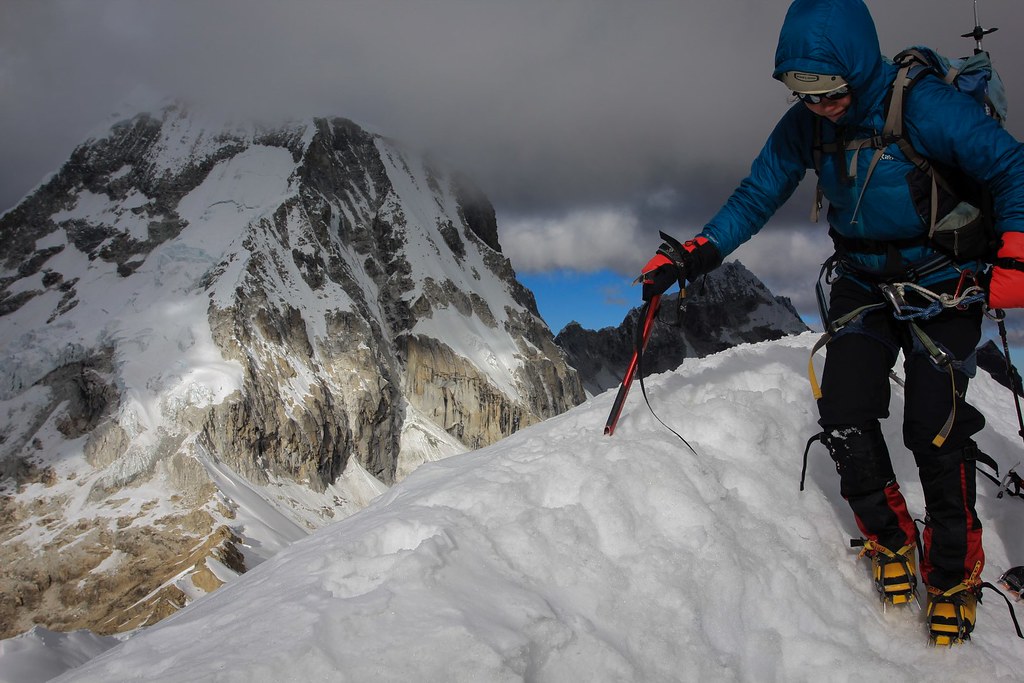
March turns into April. Magical red colours tumble down the mountain slopes, leaving only the valley floor with green toppings. It’s unuasally hot and crisp for the time of the year. You should be blown of your feet from this ridge so close to the ice cap at these latitudes. We reach a rocky outcrop. It’s all ice as far as the eye stretches west. The hue of the light is indescribable but very addictive. Milky white transcends into turquoise blue when the huge, fat glaciers breakmelt into the cold waters of the Lago O’Higgins. Sharp peaks emerge from the ice, shaking hands with the clouds. To the east, the contract of lakelight with the golden, yellow steppe leaves us stunned.

Lenga forrest turning in fairylike red in autumn. Lago del Desierto. Santa Cruz. Patagonia. Argentina.

Lenga forrest turning in fairylike red in autumn. Lago del Desierto. Santa Cruz. Patagonia. Argentina.

A snow dusting completes the picturesque views over Lago del Desierto. Santa Cruz. Patagonia. Argentina.

A snow dusting completes the picturesque views over Lago del Desierto. Santa Cruz. Patagonia. Argentina.

Routefinding over sandy grounds towards the  Loma de las Pizarras in the Los Glaciares National Park. Patagonia. Argentina.

Routefinding over sandy grounds towards the Loma de las Pizarras in the Los Glaciares National Park. Patagonia. Argentina.

There’s no way of getting bored of Patagonia. Every new visit reveals more beauty and secrets. It’s living a dream, for real and we inhale every part of it. We pass through the ranch of a lonely gaucho, set up camp, and sip mate all evening, trying to explain the complex politics of a small, bustling little country lacking any noticeable backcountry, mountain or glacier. The gaucho frowns and chuckles. Outside a full moon rises and a big chunk of ice says goodbye to the ice cap and tuffs by the ranch.

Exploring the Loma de las Pizarras ridge, with Cerro Solo (2121m) towering above the Laguna Torre. PN Los Glaciares. Patagonia. Argentina.

Exploring the Loma de las Pizarras ridge, with Cerro Solo (2121m) towering above the Laguna Torre. PN Los Glaciares. Patagonia. Argentina.

Moraine is only what's left what used to be the Glaciar Piedras Blancas. Patagonia is a huge outdoor labo for global warming. In no other part of the world glaciers are melting at this astounishing, alarming rate.

Moraine is only what’s left what used to be the Glaciar Piedras Blancas. Patagonia is a huge outdoor labo for global warming. In no other part of the world glaciers are melting at this astounishing, alarming rate.

Ñires and lenga trees struggle to get grip on the rocky ground so close to the Southern Patagonian Ice Cap. A rock throw away the golden steppes of  Patagonia yearn for winds.

Ñires and lenga trees struggle to get grip on the rocky ground so close to the Southern Patagonian Ice Cap. A rock throw away the golden steppes of Patagonia yearn for winds.

When coming down from the Pizarras ridge, we encounter these huge puma tracks around our left behind packs. Los Glaciares National Park. Patagonia. Argentina.

When coming down from the Pizarras ridge, we encounter these huge puma tracks around our left behind packs. Los Glaciares National Park. Patagonia. Argentina.

Glaciar Grande melts into Laguna Torre. Cordon Adela and world famous Cerro Torre (3133m) granite needle playing hide-and-seek in the clouds. PN Los Glaciares. Patagonia. Argentina.

Glaciar Grande melts into Laguna Torre. Cordon Adela and world famous Cerro Torre (3133m) granite needle playing hide-and-seek in the clouds. PN Los Glaciares. Patagonia. Argentina.

By the time we eventually reach Argentine’s self-proclaimed trekking capital of El Chalten, the village is allready going into close-down mode. A handfull of brave backpackers shop the couple of outdoor shops for hiring a warm sleeping and a dry tent to get them towards the bases of of the famous Fitz Roy and Cerro Torre.

The granite needles of Cerro Fitz Roy and Poincenot are proud garders of the Southern Patagonian Ice Field. Los Glaciares National Park.

The granite needles of Cerro Fitz Roy and Poincenot are proud garders of the Southern Patagonian Ice Field. Los Glaciares National Park.

Towards the base of Cerro Torre. But it's all hide-and-seek. Los Glaciares. Patagonia. Argentina.

Towards the base of Cerro Torre. But it’s all hide-and-seek. Los Glaciares. Patagonia. Argentina.

Dripping rain over the Laguna Torre. Los Glaciares. Patagonia. Argentina.

Dripping rain over the Laguna Torre. Los Glaciares. Patagonia. Argentina.

A first autumn prick dusts the upper slopes with a reflective carpet of photogenic white. Lenticulars form cartoonish figures above the golden steppe. At dusk skies are clad with gold, orange, pink and a deep blue over the horizon. With a couple of stable days ahead, we climb away out of town towards more remote, windswept ridges with more uninterupted views towards the mysterious black & white backbone of the Lautaro-range cutting the ice cap in half. At our foot spreads out the maze of crevasses of the Viedma Glacier, snaking its way through the mountains towards its namesake lake, where the ice is losing the global warming debate.

Scouting a route for crossing the Glacier Tunel towards the Paso del Viento, which is at the upperleft corner of the picture. Los Glaciares. Patagonia. Argentina.

Scouting route for crossing the Glacier Tunel towards the Paso del Viento, which is at the upperleft corner of the picture. Los Glaciares. Patagonia. Argentina.

Descending the Paso del Viento towards the side moraine of Glaciar Viedma, which forms part of the Southern Patagonian Ice Cap. The Lautaro range splits the ice cap exactly in half. Bernardo o'higgins National Park. Magallanes region. Patagonia. Chile.

Descending the Paso del Viento towards the side moraine of Glaciar Viedma, which forms part of the Southern Patagonian Ice Cap. The Lautaro range splits the ice cap exactly in half. Bernardo o’higgins National Park. Magallanes region. Patagonia. Chile.

Before the real route finding started we crossed into Hugh and Fred, 2 young Brits on a South American backpacking trip. They had little backcounty experience and seemed very happy with our company into this remote, wild place.

Before the real route finding started we crossed into Hugh and Fred, 2 young Brits on a South American backpacking trip. They had little backcounty experience and seemed very happy with our company into this remote, wild place.

High on the moraine of Glaciar Viedma. Los Glaciares. Patagonia. Argentina.

High on the moraine of Glaciar Viedma. Los Glaciares. Patagonia. Argentina.

Glaciar Viedma calves into Lago Viedma. A huge amount of condors soar high above. Los Glaciares National Park. Patagonia. Argentina.

Glaciar Viedma calves into Lago Viedma. A huge amount of condors soar high above. Los Glaciares National Park. Patagonia. Argentina.

A rest on the cross-country, undulating route towards El Chalten. Lago and Glacier Viedma. Los Glaciares National Park. Patagonia. Argentina.

A rest on the cross-country, undulating route towards El Chalten. Lago and Glacier Viedma. Los Glaciares National Park. Patagonia. Argentina.

Our idea of packrafting 2 rivers in the Torres del Paine National Park, are halted by prolonged instable, rainy and windy forecast. An Indian Summer forecast for norhtern Patagonia on the other hand, makes us decide to alter our southern course into an northern one.

A gaucho once told us, there’s nothing to be more afraid of getting lost on the desolate Patagonian Pampa, so a 2-day busride on the Ruta 40 brought us back in Bariloche, where we started our adventure back in January. As fast as we could, we left town with all gear and food for a 14-day traverse towards El Bolson, to witness the mountains, rivers and forrest surrender to autumn.

Descending into autumn on a 14-day hike along the Huella Andina route from Bariloche to El Bolson through the Nahuel Huapi National Park and Comarca Andina ranges. Lakes region. Rio Negro. Patagonia. Argentina.

Descending into autumn on a 14-day hike along the Huella Andina route from Bariloche to El Bolson through the Nahuel Huapi National Park and Comarca Andina ranges. Lakes region. Rio Negro. Patagonia. Argentina.

Lenga forrests falling into autumn. Nahuel Huapi National Park. Patagonia. Argentina.

Lenga forrests falling into autumn. Nahuel Huapi National Park. Patagonia. Argentina.

Autumn around Laguna Jacob. PN Nahuel Huapi. Argentina.

Autumn around Laguna Jacob. PN Nahuel Huapi. Argentina.

I say jump! PN Nahuel Huapi. Argentina.

I say jump! PN Nahuel Huapi. Argentina.

A frosty night on the shores of Lago Mascardi, which we explored on packraft. The nearby Rio Manso is so shallow this time of the year, we have to content ourselves with lakes. Cerro Tronador (3491m) dominates the lunar lit skyline. PN Nahuel Huapi. Argentina.

A frosty night on the shores of Lago Mascardi, which we explored on packraft. The nearby Rio Manso is so shallow this time of the year, we have to content ourselves with lakes. Cerro Tronador (3491m) dominates the lunar lit skyline. PN Nahuel Huapi. Argentina.

Rivers to shallow? Let's play on the lake then... Lago Mascardi. Argentina.

Rivers to shallow? Let’s play on the lake then… Lago Mascardi. Argentina.

Climbing up towards Refugio Otto Meiling. PN Nahuel Huapi. Cerro Tronador. Patagonia. Argentina.

Climbing up towards Refugio Otto Meiling. PN Nahuel Huapi. Cerro Tronador. Patagonia. Argentina.

Mmmm. Malbec. Argentine's finest. Refugio Otto Meiling. Cerro Tronador. Argentina.

Mmmm. Malbec. Argentine’s finest. Refugio Otto Meiling. Cerro Tronador. Argentina.

Farm-gazing. Lago Steffen. PN Nahuel Huapi. Argentina.

Farm-gazing. Lago Steffen. PN Nahuel Huapi. Argentina.

Exploring the Lago Steffen. Nahuel Huapi National Park. Argentina.

Exploring the Lago Steffen. Nahuel Huapi National Park. Argentina.

Hugging 3000-year old Alerce trees in the Valdivian rain forrest. Comarca Andina. Argentina.

Hugging 3000-year old Alerce trees in the Valdivian rain forrest. Comarca Andina. Argentina.

Stands of 3000 year old Alerce trees in the rain forrest. Comarca Andina. El Bolson. Argentina.

Stands of 3000 year old Alerce trees in the rain forrest. Comarca Andina. El Bolson. Argentina.

Gaucho crossing the Rio Azul. Comarca Andina. Argentina.

Gaucho crossing the Rio Azul. Comarca Andina. Argentina.

With the last rosty leaves to cover the forrest floors, it’s time to settle the last 4 months of venturing into the backcountry of our beloved Patagonia. We accumulate a total of 1 year exploring Patagonia from 3 prolonged trips spread over 5 years. In some places locals start to recognize us from previous years and invite us for a talk over mate. Some are stunned on how detailed we know some remote corners of this pristine corner of the world, altough we feel we only start to know our way through this huge empty space of wild.

Will we be back? There’s a legend that says “the one who bades in the Rio Limay, will come back a lifetime to Patagonia”. We’ve been swimming and packrafting this pristine river back in January 😉

Time flies by. We have 3 months left from our gap year. Let’s head north to Colombia and Peru to meet some old friends…

For more pictures from our last 5 weeks rambling Deep Patagonia, please click:

Lago O’Higgins
Los Glaciares
Huella Andina

Catch you on the flip side! Thanks for coming by to our blog. We're off to Colombia and Peru now...

Catch you on the flip side! Thanks for coming by to our blog. We’re off to Colombia and Peru now…

Quien se apura en la Patagonia, pierde el tiempo

(the one who hurries through Patagonia, wastes time)

The Chilean Patagonian region of Aysén, has been the remotest corner of the southern cone for centuries. Only recently the region has been connected to the outside world through the construction of the Carretera Austral, a 1200 km long dirt road, connecting fishing villages in the archipelago and settlements along the Andean mountains sculptured by the reatreating Northern Patagonian Ice Field.

The Rio Ibanez basin as seen descending from the Cerro Castillo ridge. Aysen, Patagonia, Chile.

The Rio Ibanez basin as seen descending from the Cerro Castillo ridge. Aysen, Patagonia, Chile.

Nevertheless it remains difficult to reach and only determined tourists intrude its isolation, altough it has huge potential for any kind of adventure. And there is still a lot to be explored, to say the least. This is Patagonia at its purest. Mountains, huge glaciers, fjords, deepblue fishrich lakes, native dense forests, shy fauna and true surviving, hospitable gaucho culture.

Huemul or Andean deer. An estimated 2000 animals of this endangered deer species are left in Patagonia. We met this young, curious male while hiking through the Reserva Nacional Cerro Castillo.

Huemul or Andean deer. An estimated 2000 animals of this endangered deer species are left in Patagonia. We met this young, curious male while hiking through the Reserva Nacional Cerro Castillo.

Previous trips through this little inhabited region had us been rushing through on the way towards the more famous attractions in the south, but not this time. We were detemined to explore thoroughly this time. So, the last 6 weeks we have been sort of thru hiking the region by following old gaucho routes who used to be the only connection between the settlements before the Carretera Austral came.

Patagonian night. Playing by the fire...

Patagonian night. Playing by the fire…

Aysén is threatened by a plan to build five hydro-electrical dams on the Baker and the Pascua rivers, two of the purest and wildest in the world. This could become an ecological disaster, affecting ecosystems for endangered species, who already have to fight loss of habitat from huge, manmade, unnecessary forest fires in the past. Luckily their are great conservation initiaves like the new proposed Future Patagonia National Park, which has huge touristic potential, becoming a new Torres del Paine.

We leave the region, with even more ideas then before. I could write a book on the adventure and ecotouristic opportunities here. Maybe a future project 🙂

Please come here to float it’s rivers and hike its ridges. Because that is what you really can do to preserve this pristine corner of the world. Tourism is Aysén’s future and answer for conservation.

The following series of pics is our trip report from and ode to Aysén and to a Patagonia without dams. Patagonia sin Represas! Reserva de Vida! Rios libres!

Exploring a wild ridge in the Reserva Nacional Cerro Castillo. Aysen, Chilean Patagonia.

Exploring a wild ridge in the Reserva Nacional Cerro Castillo. Aysen, Chilean Patagonia.

Beard lichen is omnipresent in the dense, pure Patagonian lenga forrests.

Beard lichen is omnipresent in the dense, pure Patagonian lenga forrests.

Dry them runners...

Dry them runners…

The rugged ranges and a good trail begin to attract tourists into the diverse Reserva Nacional Cerro Castillo. Aysen, Patagonia, Chile.

The rugged ranges and a good trail begin to attract tourists into the diverse Reserva Nacional Cerro Castillo. Aysen, Patagonia, Chile.

Approaching San Lorenzo. A huge, glaciated mountain range on the border with Argentina, and a last stop for Patagonian storms to drop their content before blowing off into the steppes. Aysen, Patagonia, Chile.

Approaching San Lorenzo. A huge, glaciated mountain range on the border with Argentina, and a last stop for Patagonian storms to drop their content before blowing off into the steppes. Aysen, Patagonia, Chile.

A curious Condor flies over the ridge, investigating the small moving dots in its habitat. San Lorenzo range. Aysen. Patagonia. Chile.

A curious Condor flies over the ridge, investigating the small moving dots in its habitat. San Lorenzo range. Aysen. Patagonia. Chile.

Glaciar d'Agostini flowing down from the San Lorenzo range. Aysen. Patagonia. Chile.

Glaciar d’Agostini flowing down from the San Lorenzo range. Aysen. Patagonia. Chile.

The San Lorenzo massif in all it's glory. Aysen. Ruta de los Pilcheros. Patagonia. Chile.

The San Lorenzo massif in all it’s glory. Aysen. Ruta de los Pilcheros. Patagonia. Chile.

Patagonian gaucho on the forgotten mountain routes of remote Aysen. Patagonia, Chile.

Patagonian gaucho on the forgotten mountain routes of remote Aysen. Patagonia, Chile.

More beard lichen of lenga trunks.

More beard lichen of lenga trunks.

Diversing into Argentine soil on the Ruta de los Pilcheros. Aysen, Patagonia, Chile.

Diversing into Argentine soil on the Ruta de los Pilcheros. Aysen, Patagonia, Chile.

Don Rial Heraldo. Patagonian gaucho, living in a far-off radar valley, deep in the Andean mountains, a 4-day horseback ride to the nearest town of Cohrane. We sip yerba mate all afternoon and can't stop laughing with all his stories and jokes he fires at us while a storm approaches outside. Aysen, Patagonia, Chile.

Don Rial Heraldo. Patagonian gaucho, living in a far-off radar valley, deep in the Andean mountains, a 4-day horseback ride to the nearest town of Cohrane. We sip yerba mate all afternoon and can’t stop laughing with all his stories and jokes he fires at us while a storm approaches outside. Aysen, Patagonia, Chile.

Gaucho stove...

Gaucho stove…

Bivaouc at Don Rial's house. Aysen, Patagonia, Chile.

Bivaouc at Don Rial’s house. Aysen, Patagonia, Chile.

Ready for crossing Lago Alegre. Aysen, Patagonia, Chile.

Ready for crossing Lago Alegre. Aysen, Patagonia, Chile.

Over and along slabs. Lago Alegre, Aysen, Patagonia, Chile.

Over and along slabs. Lago Alegre, Aysen, Patagonia, Chile.

Dark clouds gather above the tiny church of Cochrane. Aysen, Patagonia, Chile.

Dark clouds gather above the tiny church of Cochrane. Aysen, Patagonia, Chile.

Lonely guanaco in the valle Chacabuco. Future Patagonia National Park. Aysen. Chile.

Lonely guanaco in the valle Chacabuco. Future Patagonia National Park. Aysen. Chile.

A clear night in the Aviles Valley. Future Patagonia National Park. Aysen, Chile.

A clear night in the Aviles Valley. Future Patagonia National Park. Aysen, Chile.

Hiking up north into the wild Jeinimeni Reserve. Future Patagonia National Park. Aysen, Chile.

Hiking up north into the wild Jeinimeni Reserve. Future Patagonia National Park. Aysen, Chile.

Exploring up side valleys. Valle Hermosa. RN Jeinimeni. Future Patagonia National Park. Aysen, Chile.

Exploring up side valleys. Valle Hermosa. RN Jeinimeni. Future Patagonia National Park. Aysen, Chile.

Valle Hermosa. RN Jeinimeni. Future Patagonia National Park. Aysen, Chile.

Valle Hermosa. RN Jeinimeni. Future Patagonia National Park. Aysen, Chile.

Lago Verde. Valle Hermosa. RN Jeinimeni. Future Patagonia National Park. Aysen, Chile.

Lago Verde. Valle Hermosa. RN Jeinimeni. Future Patagonia National Park. Aysen, Chile.

A shelter in the Valle Hermosa. RN Jeinimeni. Aysen, Chile.

A shelter in the Valle Hermosa. RN Jeinimeni. Aysen, Chile.

Preparing for a float down Rio Nadis. Baker basin. Aysen, Patagonia, Chile.

Preparing for a float down Rio Nadis. Baker basin. Aysen, Patagonia, Chile.

Packrafting the Rio Nadis. Aysen, Patagonia, Chile.

Packrafting the Rio Nadis. Aysen, Patagonia, Chile.

Packrafting the Rio Nadis. Baker basin. Aysen, Chile.

Packrafting the Rio Nadis. Baker basin. Aysen, Chile.

Refugio Los Nadis. Baker basin. Aysen, Patagonia, Chile.

Refugio Los Nadis. Baker basin. Aysen, Patagonia, Chile.

Asasdo de Cordero. Roasted Lamb. Los Nadis. Aysen, Chile.

Asasdo de Cordero. Roasted Lamb. Los Nadis. Aysen, Chile.

Marking of the Calves. Los Nadis. Aysen, Chile.

Marking of the Calves. Los Nadis. Aysen, Chile.

Marking of the calves. Los Nadis. Aysen, Chile.

Marking of the calves. Los Nadis. Aysen, Chile.

Marking of the calves. Los Nadis. Aysen, Chile.

Marking of the calves. Los Nadis. Aysen, Chile.

Rancho los Nadis. Baker basin. Aysen, Chile.

Rancho los Nadis. Baker basin. Aysen, Chile.

The mighty Baker River. Aysen, Chile.

The mighty Baker River. Aysen, Chile.

The boardwalks of sleepy fishing settlement Tortel. Aysen, Chile.

The boardwalks of sleepy fishing settlement Tortel. Aysen, Chile.

Sipping Mate at the Baker's mouth in the Pacific. Aysen, Chile.

Sipping Mate at the Baker’s mouth in the Pacific. Aysen, Chile.

Tortel's bay. Aysen, Chile.

Tortel’s bay. Aysen, Chile.

For more pictures from our last 6 weeks in this remote corner of Patagonia, please click:

Sendero de Chile – RN Cerro Castillo
Ruta de los Pilcheros</a
The future Patagonia National Park
The Baker basin

Rest by the fire. Gaucho hospitality. Aysen. Chile.

Rest by the fire. Gaucho hospitality. Aysen. Chile.