Springtime. Daylight starts to win over dark. Trees turn into green. The morning air is filled with aromas. People get out, smile and look happy. Jogging and cycling seem like a plague again. It’s the time of the year that the house get scattered with winter outdoor gear, tiny plastic food ratio bags and folded open maps from remote wilderness areas far north. The food drying machine is running overtime, filling the house with strange odors.
We pack up and fill the Pulka with down jackets and sleeping bags, a 4-season tent, merino wool socks and heaps of enthusiasm. The carry-on luggage is exploding. We need some kind of plan to bypass the strict lady at the check-in counters. Luckikly i have big teeth and lips which can stretch from ear-to-ear.

Sorting out gear at the STF-"Butik" in Ritsem after 24-hour travel from Belgium. Stora Sjöfallet National Park. Sweden
A 2-hour flight, a 45-min time gap for the Stockholm-white-gas-quest, 17 hours of railroading and 4 hours of bus-speeding over glassy roads trough never-ending boreal forests. Suddenly the majestic, white mountains fill the bus window again. Every time again, it shivers down our spine. Adventure is approaching.
The ice stalactites are dripping in the sun at the small shop in Ritsem. A Saami comes by and wishes us good luck. “It has been very nasty the last couple of weeks. It’s the first day in weeks since I saw this kind of blue”.

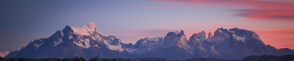
Crossing Akkajaure with Áhkká mountain massif behind. Stora Sjöfallet National Park. Sweden
We buckle the rods around our waist and shoulders and leave for a 2-week traverse into Laponia. We cross the solid frozen Akkajaure while the sun sets ahead. We meet Markus Heim, who flatly proclaims his 86th days on skis. The grin on his face, the length and colour of his beard blabs out an epic adventure. His girl is awaiting him at the other side of the lake. I urge him to stop spending his time on me. His compass designates north, ours south-east.
")
Entering the Sarek under the watchful eye of Niják (1922m)
We cross into Sarek National Park. There are no traces from previous passer-bies. It’s so virgin here. We continue in base layer. A small breeze reminds us that it’s still -8°C and not summer. I always forget how fast my fingers congeal with such blows from nowhere. Mr. Bolt can learn something from the speed I reach for the primaloft-layer. Perfect conditions. Me like.
Leaving the warm nest in the tent for snapping 2AM norhtern lights pics in a breezy -25°C, is something on which some people would point with their finger to the sides of their head. But man, I am willing to make some shaking sacrifices for this spectacle.

Northern lights above Skarja. Sarek NP
Deep cut valleys make it childishly easy for navigation. Leaves us loads of time to swallow the landscape. Ouch. Topsy-turvy. This can satisfy my hunger. Some of them rock faces are way too steep from this side. Snow is playing with gravity-rules there (if Newton would have known!). The Ruohtesvagge-valley does not fail to dissapoint. Even in bad weather this must be beautiful.
The lack of shelter combined with the shifting weather and rough terrain require hikers to have considerable experience to safely explore the area. Very few bridges are available inside the park and crossing streams (jokk in Sami) and rivers (ätno in Sami) can be very dangerous for the ill equipped or inexperienced. – writes Wikipedia. Luckikly everything is silently frozen white. Makes its easy to float by on snow flappers.

Ähpár massif and Skarki-massif scatter the horizon
Skarja could count as a wilderness intersection. Here we meet the first human being in days. Otto, a pleasant Swedish fellow, is here to ski down the forementioned gravity-defying faces. He is a nice companion while gazing in the sun. We agree on “Awesome” as the appropiate term for this heavenly place on earth. While the temperature drops below what we could measure, stories from our adventures in the Karakorum mountains in Pakistan, nourish Otto’s dreams on this far-away-destination of which Sarek reminds us.
 summits of Sarek NP")
Sarektjahkka-massif, the highest (2089m) summits of Sarek NP
We tried to capture our small adventure in Sarek in the following shortfilm:
.
Bloody Mary, a new lightweight girlfriend for the coming exciting year
We have underestimated the night temps in this clear weather. Our fresh from the shelf 3-season Bloody Mary promises us that she will be a trustfull girlfriend, willing to go over her boundaries if necessary, altough we have to beef her up with a downjacket in this temperatures. It has been an nice acquaintance Mary. You deserve your own blogpost. That’s right!
")
Following Rahpajahka along Laddebakte (1537m)
The second morning at Skarja we wake up with noizes from outside. It’s like somebody is talking. When cleaning out the morning ear-and eyewax, it becomes clear that Mr. High Pressure had changed chairs with Mr. Cold Front. Snow is drifting trough the valley from all sides. It’s like all dust has to be collected at this intersection. We break up camp and leave in the white-out. Destination Rovdjurstorget, the place where Rapadalen is born. This place is more popular called Predator Square. I wonder why? It’s so Bambi quiet in here.

ET's life would have been lot more easier with this SPOT GPS Satellite Messenger
When we taught Sarek had offered us all we had came for, we needed to traverse one more valley. A new high pressure sets in. Why did nobody warned us on Rapadalen? That’s not a valley. That’s extravaganza. How can we absorb all this? Pfffff. In a couple of months we’ll come back here. A packraft will be necessary,….
Ok, I can’t continue describing all this… so let’s end with some more stills.
Now I hear you talking.
Oooo, before I forget, this was the last time we came in snow shoes. We have enough of the eyebrow frowning born-with-skis-on-their-feet-Scandinavians. Yeah yeah, we’ll join your club of slats-addicts.
Speak soon. Peace out!

Rapadalen. Nature extravaganza.

Skierfe, Nammasj and Tjahkelij proudly guard the eastern entrance of Sarek
, a sheer 700m cliff... pride guard of Sarek")
SKierfe (1179m), a sheer 700m cliff... pride guard of Sarek

Skierfe and Nammasj, guarders of Rapadalen

Two dreamers at 67°N

Destination Kvikkjokk... lonely on the Kungsleden.

Northern lights... need to say more?
Please visit my online album from this trip…
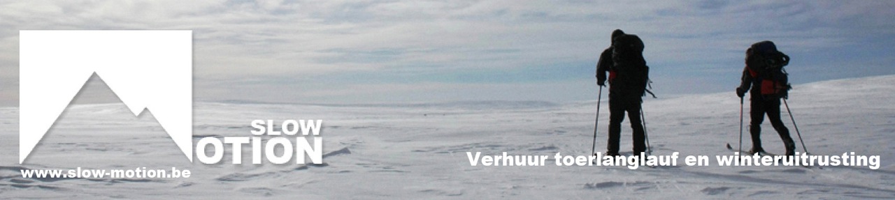
Affiliate sponsorship (in dutch)
Slow-Motion verhuurt toerlanglaufski’s, stijgvellen, pulka’s, tenten en allerlei expeditiemateriaal voor wintertochten. Bekijk ons aanbod onder verhuur!

 and 850gr MSR Twing Tarp (right), Llinera-valley, East-Greenland")


")
")
")
")
")
")


, coming from the Lammerenhutte")

)")

")
 as seen from near Heuberg (1940m)")

