[edit 2013 – the GoLite Pinnacle is not fabricated anymore, they changed the name to GoLite JAM]
The European Alps prepare themselves for the harsh winter to come. Farmers and their cattle already descended into the lower valleys. Wildlife roams below the edges. Tourists are long gone. Late autumn is a delight to go hike in the (Swiss) Alps.

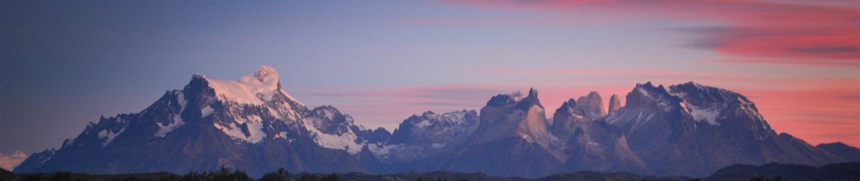
Hohtürli - Blüemlisalp
For us it’s a no brainer to plan a hike in the Swiss Alps. A 7.5 hour drive takes us right in front of the massive wall that forms the Bernese Wall. Folding open the map, eyes closed, we point out a direction from our starting point Kandersteg for a 4-day hike. A persistent and (for the time of the year) unusual south Foehn provokes a real indian summer in the northern Alps, unfolding clear blue skies and summer temperatures into the valleys.
We both are childishly eager to test our new lightweight backpacks: the GoLite Men’s 72L/935g and Women’s 63L/877g Pinnacle Pack! We also have the intention to test our new Therm-a-Rest Neo Air All Seoson, but short daylight hours, long hiking hours, coincidence and lazyness failed us to bivaouc so we got comfy sleeps in the empty winter raums of the widespread Swiss mountain huts.

GoLite Pinnacle men's 72L Pack, weighing only 935g
On the first day we walk upwards trough golden larches in the direction of Wildstrubel (3243m) up in the wide Schwarenbachtal (following an, out of this world, ugly high power line cutting trough the valley). We wave hello towards the snowdusted Altels (3629m), the glaciated Balmhorn (3698m) and craggy Rinderhorn (3448m).
, coming from the Lammerenhutte")
Lammerental towards Rote Totz (2848m), coming from the Lammerenhutte
In the ascent towards the Lammerenalp we pass by the almost fully dried up Daubensee (2207m) and on our left side we see the closed hotel on the Gemmipass (2314m). We have the intention to bivaouc somewhere in the snowed and shady Lammerenalp but then we see the Lammerenhutte above a rock outcrop and head for the winter raum, arriving just before dark.

Spot Emergency Beacon, from Rote Totz Lucke with a southern view towards Valais Alps
On the second day we follow the icy Lammerental, passing a herd of Chamois, climbing towards snow covered Rote Totz Lucke-ridge from where we have a clear view towards the Valais Alps. We are right on the border of Berner Oberland with Valais. We descend towards the Uschenentall, crossing the Talligletsjer.
)")
Perfect fit of the WM's GoLite Pinnacle, on the Talligletsjer under the granite wall of Steghorn (3146m)
What a beautiful, forgotten high alpine glen this is! We enjoy the silence, the icy and snowy passages and clear blue skies that lead us, passing the frozen Talliseeli-tarn towards the Usser Üschene valley. We descide we want to reach Fisialp high above the Oeschinen Lake, which is an UNESCO World Heritage Site. Once there, we continue in the dusk light towards the Doldenhorn Hutte.

Snowy descend toward the Usser Üschene valley
On our thirth day we explore the area around under the Doldenhorn (3475m) and descide to descend towards the Oeschinen Lake and try to reach the Blüemlisalphütte (2840m). The area around the Unesco protected lake is outstanding beautiful and we are astonished that on such a sunny day there is nobody around! The place is just silently empty. We can imagine how busy it could be here in summer.
")
Dusk at The Blüemlisalphütte (2840m)
In a couple of hours we reach, on a quite easy trail, just before sunset the beautifuly located hut. It stands proud above the heavily crevassed Blüemlisalpglacier and under the guarding, icy summits of Morgenhorn (3623m), Wyssi Frau (3650m) and Blüemlisalphorn (3661m).
On the firth day we descend towards Kandersteg, passing by the Heuberg (1940m), with tremendous view towards the azure Oeschinen Lake.
 as seen from near Heuberg (1940m)")
Oeschinen Lake (1578m) as seen from near Heuberg (1940m)
What about the GoLite Pinnacle Pack?
We started with a winter base weight of 7552gr (including winter down sleeping bag, crampons, down jacket,…) plus food, fuel, water,… to a total of 11kg550gr. The manufacturer specifies a comfortable to carry load of max. 18kg, which really is the max. weight we would put in this pack.

GoLite Pinnacle Pack Men vs Women
The frameless pack fits unbelievably pefect to the back spine if the load is organised bulky enough to give support enough to your entire back. The padding on the hips is small, compared to heavier “standard” packs, but spreads the weight very well towards the hips. The biggest difference with “standard” packs, is the lack of the hood, with which you would normally close your pack. Now there only remains a cord strap and clip system (you close the pack as you would close a dry bag). As the pack is not waterproof (only water resistant), you should pack your valuable gear in waterproof bags, but that’s also the case with “standard” packs. We also like the side straps which will enable us to put gear “outside the pack” in future trips. With small straps you can also make the pack unbelievalbe small like it resemble a daypack (see in our flickr photostream)! There is a big zipped front pocket for storing small, quickly accesible items like maps, torches, …
Are we happy with the pack? Ooooooh yeaaaah!

I like my Golite Pinnacle, but you have to pack it carefully to make sure stuff doesn’t stick in your back. Great for winter day walks and backpacking when you have a lot of bulky winter gear. I can get my snow shoes in the side pockets. The photos are excellent in this trip report. Brings back memories of walking when I was in my early twenties in this excellent area of the alps.
its a great pack. Even better was the walk and photos you shared of it.
PS I sold my Pinnacle. I slightly regret it.
Beautiful place! The image of Oeschinen Lake i stunning 😀
Cheers,
Mikkel
Pingback: Undulating snow on the Vercors Plateau (French Alps) « patagonian dreams